 Skip to content

Construction Technology
In May 2012, Fermi 2 received the U.S. nuclear energy industry’s highest accolade, the Top Industry Practice (TIP) award, from the Nuclear Energy Institute. The recognition was made possible by Mid-American Group’s innovative and safety-driven solution, which utilized a robotic dry ice system to address a critical operational challenge.
Fermi 2 needed to clean contamination from hard-to-access HVAC ductwork. Our team provided the cutting-edge technology and skilled personnel necessary to complete the task safely and efficiently, setting a new standard for industry best practices.

Drone Inspection

Mavic 3
Mavic 3 is a professional-grade drone equipped with a Hasselblad 4/3 CMOS camera.
– Captures 20MP stills and 5.1K video
– Ideal for high-resolution aerial imagery
– Up to 46 minutes of flight time
– Advanced obstacle sensing
– Precise GPS positioning

RTK350
The Matrice 350 RTK is a rugged, enterprise-level drone designed for tough construction environments.
– Centimeter-level positioning accuracy
– Max flight time: 55 minutes
– Modular payload system supports: High-res cameras, LiDAR,
Thermal sensors

M30T
The M30T offers a balance of power and portability in a compact, weather-resistant build.
– 48MP zoom camera
– 640×512 thermal imaging
– Wide-angle lens
– Laser rangefinder
– Up to 41 minutes of flight time
Drone Experience

DTE Fermi 2 Nuclear Power Plant Stack Inspection
Consumers Energy
Stack Inspection for cracks
Internal Boiler Inspection
Detroit Thermal at GM Hamtramck Pipe Lift Inspection
ABB Filming of Robotic Assembly line for Ford Motor Company
Floor Monitoring for the city of Dundee, MI
Farm crop growth coverage inspections, Newport, MI
Drone Capabilities
FAA waiver for commercial operation
FAA certified Pilots
FAA qualified technicians
Infrastructure Management / Inspection
Assessment Monitoring
Infrared thermal imaging
Videography
Disaster support
Perimeter inspection
Stack / tank / bridge / pipline / rail / tower / roof
Cracks / liner / wear inspection
Security monitoring

GROUND PENETRATING RADAR
Stepped Ultra Wideband Pulses merge the benefits of pulse radar and stepped frequency radar, delivering unmatched resolution and depth. With the integration of advanced Direct RF sampling technology, these systems produce clearer and more intuitive images, surpassing the capabilities of older radar technologies.

US RADAR QUANTUM SURFACE IMAGING SYSTEM
Duribility
MIL-STD-810G, 4-foot drop and all-weather IP65 dust and water resistant design
Display
10.1-inch, HD daylight-readable, ten-point multi touch + digitizer
Interface and Expansion
USB 3.0 + HDMI ports; optional
Wireless
Wi-Fi, Bluetooth® and optional 4G LTE or 3G Gobi™
-
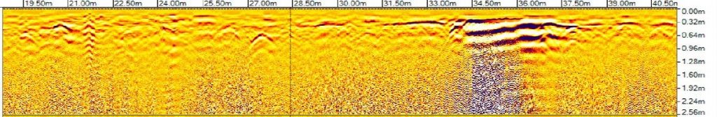
- 2-D GPR SCANNING RESULTS

-

- 3-D GPR SCANNING RESULTS

A slice can be taken from the 3-D data to show the exact depth and travel path of an underground Obstruction.
This shows an 8″ HDPE pipe buried at a depth starting of about 2.7′ below the surface.

WATER STORAGE TANK LOCATION USING GPR
The GRP features radar integrated with Global Positioning Satellites (GPS), enabling seamless data transfer directly into Google Earth. This allows the precise location and depth of underground obstructions identified during a GPR analysis to be stored and plotted on Google Earth. These records can be used for creating detailed drawings or documenting subsurface conditions with accuracy and ease.

Best Tank Location for excavation identified (Circle). Locations chose to minimize the potential for encountering obstructions within the given design space (Rectangle).